Strategic Housing Land Availability Assessment (SHLAA) Explained


A Strategic Housing Land Availability Assessment, or SHLAA, is a mandatory study for all local authorities in the UK. It serves as a comprehensive overview of potential land parcels within their jurisdiction that could be suitable for residential or employment-related development.
Understanding the function of a SHLAA is crucial for property developers, land promoters, and investors who aim to align their strategies with local planning policies.
The Purpose of SHLAA
The primary goal of a SHLAA is to identify and evaluate land availability for future development, acting as an early indicator of a local authority's development capacity and potentially highlighting any shortfalls in meeting housing targets. It informs the planning process by:
Identifying potential sites for new housing;
Estimating the number of homes each site could accommodate;
Providing a timeline for when these sites might be developed, assuming suitability.
It's important to note that while the SHLAA identifies available land, it does not automatically designate sites for development. Instead, it offers a range of options to help the local authority meet its development needs.
How the SHLAA Process Works
While specific methodologies can vary, the SHLAA process generally involves the following stages:
Call for Sites: Local authorities initiate a public call, inviting submissions of land from owners, developers, and other stakeholders for potential assessment. This generates an initial comprehensive list of sites;
Initial Assessment: Each submitted site undergoes an evaluation against key criteria and potential limitations, such as minimum size, accessibility, infrastructure availability, alignment with local planning policies, and any environmental or heritage constraints;
Shortlisting: Sites that meet the preliminary criteria are included in the SHLAA report as potentially suitable for development. Shortlisting does not guarantee development will occur;
Publication and Review: The SHLAA report is published and updated periodically, typically every one to five years, providing developers with ongoing insights into land supply.
Sources for identifying larger development sites often include previous SHLAA reports, local development plans, sites with existing planning permission, submissions from the call for sites, and capacity studies.
Following identification, sites are mapped, their development potential is assessed, and they are categorised based on planning and physical feasibility.
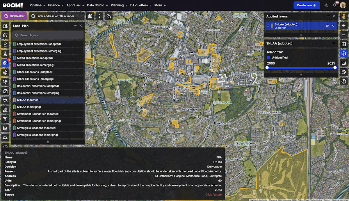
Key Data Included in a SHLAA
Each entry in a SHLAA typically provides the following information:
Site name and its geographical location;
The decision status regarding its suitability (e.g., Deliverable, Developable, Not Developable);
An estimate of its housing capacity in units;
A projected development timeframe (e.g., 0–5 years, 6–10 years);
The reasoning behind the decision status, explaining the site's suitability or any identified constraints.
This detailed information provides a comprehensive understanding of the likelihood and timing of potential land development.
Importance of SHLAA for Developers
For land promoters and property developers, the SHLAA offers significant advantages, including:
Early identification of potential land for housing development;
Understanding local council land supply and housing objectives;
Guidance for sourcing off-market development opportunities;
Supporting evidence for planning applications and appeals.
By focusing on sites already recognised as potentially suitable by the local authority, developers can mitigate planning risks and better align their projects with identified local housing needs.
Accessing SHLAA Data in the UK
Local authorities are required to publish their SHLAA reports and site lists online. However, the format and accessibility of this data can vary considerably between councils, ranging from PDF documents to spreadsheets, which can complicate navigation and searching. Specialised tools like BOOM! offer a valuable solution by organising and standardising this information, making it more accessible and user-friendly.
Leveraging SHLAA for a Smarter Land Strategy
Integrating SHLAA data into your land acquisition strategy enables you to:
Pinpoint off-market land with development potential;
Prioritise sites with a higher likelihood of obtaining planning approval;
Understand opportunities based on their decision status and anticipated delivery timeframe;
Understand future hot spots and areas of growth;
Enhance strategic targeting by combining SHLAA data with demographic and infrastructure information.