Settlement Boundary Secrets: How Planners Decide What Gets Approved


If you're new to property development, settlement boundaries are something you need to understand early on. Most developers overlook them, yet they can make or break your planning application. Here’s how planners really use them, and how you can turn this knowledge into your competitive edge.
What Is a Settlement Boundary (and Why Should You Care)?
A settlement boundary (sometimes referred to as village envelopes or development limits) is a line drawn around a town or village by the local authority. Settlement boundaries mark areas where development is broadly acceptable in principle. Land inside the boundary is considered part of the built environment. Land outside is treated as open countryside, even if it's metres from existing houses.
This boundary is not just symbolic. It’s a key spatial planning tool used by councils to manage growth, protect the countryside, and ensure housing, employment, community and recreational development happens in the right places. Understanding where this line is—and what it means—can save you thousands in wasted planning applications.
How Planners Use Boundaries to Filter Applications
Planning officers use the boundary as a first filter. If your site is within the boundary, your application benefits from a presumption in favour of sustainable development subject to all relevant policies and plans. It doesn’t guarantee approval, but it gives you a strong start.
If your site is outside the boundary, it faces heavier scrutiny. Development is usually resisted unless it meets strict exceptions—like rural exception housing or agricultural dwellings. In short, you need a stronger case.
Boundary Flexibility: It’s Not Always a Hard No
Just because a site falls outside the boundary doesn’t mean all hope is lost. In reality, boundaries are not immovable. Councils under pressure to meet housing targets—especially where they lack a five-year housing land supply or are performing poorly in terms of their housing delivery targets—can be more flexible.
Neighbourhood plans, which are often more up to date than Local Plans, can also influence how boundaries are interpreted. If a local community supports development, planners may be open to modest, well-designed schemes outside the line.
Key Factors That Influence Planning Decisions Near Boundaries
Here’s what planners consider when assessing sites near or outside settlement boundaries:
Housing need: If the council is missing its targets, your case strengthens;
Location: Is the site close to amenities and public transport?
Precedent: Have other developments been approved just outside the boundary recently?
Design: A well-designed scheme that integrates with the village edge is more likely to succeed.
Case Example: Approval Just Outside the Line
In 2023, a developer secured planning for six homes in Wiltshire, just beyond the village boundary. The council lacked a five-year housing supply, and the design was high-quality and reflected local character. Community engagement helped reduce objections.
The lesson? Boundaries matter—but they’re not everything.
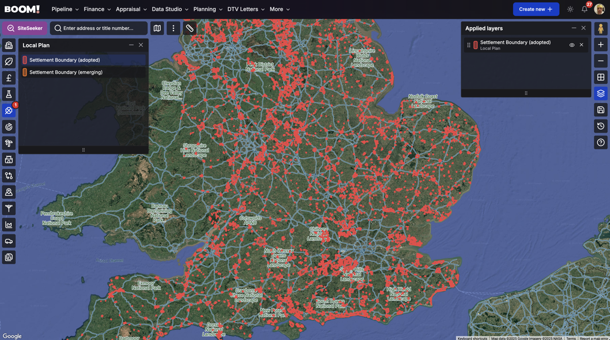
How to Find Settlement Boundaries (and Read Between the Lines)
Use BOOM!'s:
approximately 10,000 adopted and emerging settlement boundaries as a clearly defined boundary layer;
SiteSeeker to search for sites within settlement boundaries by adding settlement boundaries as a constraint;
Housing Delivery Test layer to analyse Council's Years of Housing Land Supply (YHLS) and housing delivery performance against the Housing Delivery Test to target underperforming Council's;
Review ongoing Local Plan consultations—boundaries often change.
Conclusion: Use Boundary Knowledge as a Planning Tool
Settlement boundaries are more than lines on a map. They’re used every day by planners to assess what gets approved and what doesn’t. By understanding how they work—and when flexibility applies—you’ll be better equipped to source sites, shape your proposals, and avoid rejection.
Want to stay ahead? Start by checking your local boundary maps and recent planning decisions. Knowledge of the rules means you’ll know when—and how—to bend them.
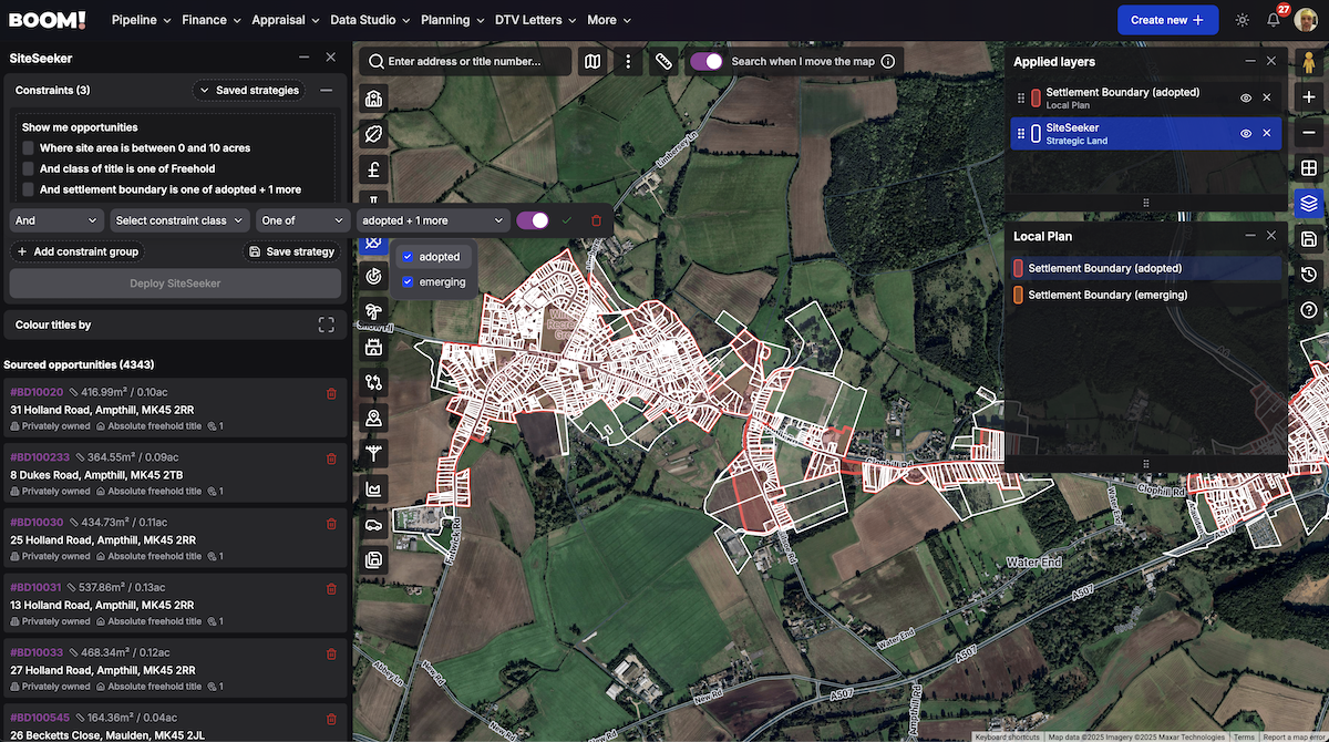
How BOOM! Makes Identifying Settlement Boundaries Effortless
BOOM! simplifies how you assess a site’s location in relation to settlement boundaries — a critical factor in planning decisions. Our dedicated layer clearly maps boundary lines, so you can instantly see whether a site sits inside or outside an area where development is more likely to be supported.
This data is fully integrated into SiteSeeker, enabling you to view the raw boundary information and apply it as a constraint within your site sourcing strategy. It’s a faster, smarter way to target sites with real planning potential.