The “Default Yes” Revolution: How Station-Based Development is Unlocking the UK’s Next Housing Boom


The landscape of British property development is undergoing its most significant shift in a generation. For years, the industry has grappled with a planning system often described as "sclerotic"—a gauntlet of "no" that has stifled growth, hampered SME developers, and left the country with a chronic housing deficit.
However, the tide is turning. The government’s recent announcement that housebuilding around train stations will be given a default “yes” marks a fundamental pivot in national planning policy. This isn't just a minor tweak to the National Planning Policy Framework (NPPF); it is a clarion call for a new era of Transit-Oriented Development (TOD).
At BOOM!, we’ve been tracking these policy shifts closely. Our mission has always been to level the playing field for developers by providing the data needed to find off-market gems. In response to this landmark policy, we have integrated new, precision-engineered data layers into our platform to help you identify these "default yes" opportunities before the rest of the market even knows they exist.
Decoding the “Default Yes”: What Does It Actually Mean?
The core of the government’s proposal is simple yet radical: to create a "presumption in favour" of sustainable development on brownfield land and underutilised sites within close proximity to transport hubs.
Traditionally, developers have had to prove why a project should be built. The “default yes” policy flips the script. In designated zones around railway stations, the burden of proof shifts toward the local authorities. If a proposal meets basic quality and safety standards, the starting point for the planning committee is an approval.
Why Train Stations?
The logic is rooted in two of the biggest challenges facing the UK: the housing crisis and the climate emergency.
Sustainability: By densifying housing around rail hubs, we reduce car dependency. This aligns with Net Zero goals and simplifies the "Sustainability" section of any planning application.
Economic Vitality: Higher density near stations supports local businesses and ensures that the infrastructure to support new residents is already in place.
The "Grey Belt" and Brownfield Focus: The policy specifically targets underutilised land—think old car parks, dilapidated industrial units, or "grey belt" land that offers little environmental value but massive logistical potential.
The 800m and 1000m Goldmine: The New Geometry of Site Sourcing
In the world of urban planning, distance is everything. The "15-minute city" concept relies on the "pedestrian shed"—the distance a person is willing to walk to access essential services or transport.
The government’s focus is on the immediate radius surrounding stations. This is where BOOM! provides a decisive competitive advantage.
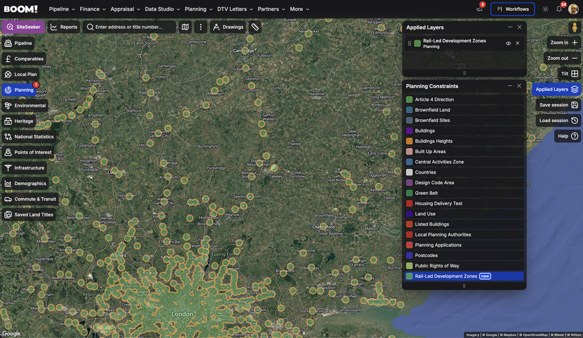
We have just launched a dedicated Rail-Led Development Zones data layer. This layer identifies sites within two critical thresholds:
800 Metres: Roughly a 10-minute walk. This is the "Prime Zone" where planning weight is heaviest and the "default yes" is most robust.
1000 Metres: Roughly a 12-to-15-minute walk. This is the "Growth Zone," capturing the outer edge of station influence where land values might be more competitive, but the policy support remains significant.
By visualising these zones directly on our map interface, you can instantly see which parcels of land fall into this new high-probability planning category.
Beyond the Map: Using SiteSeeker to Filter for Success
Identifying a zone is one thing; finding a viable, off-market site within that zone is another. This is where our SiteSeeker tool becomes your most valuable asset.
We haven't just added a visual layer; we’ve added these distances as constraints.

How it works for you:
Instead of manually scrolling through satellite imagery, you can now set your parameters in SiteSeeker:
Select Location: Choose your target town or region.
Apply Rail-Led Development Zones Constraint: Filter for sites specifically within 800m (default yes) or 1000m (possible) of a rail station.
Layer Your Constraints: Add other filters such as "Brownfield Land," or specific "Use Classes" types (e.g., Class E).
Identify Ownership: BOOM! pulls the ownership data, allowing you to bypass the agents and go directly to the source.
This allows you to generate a shortlist of high-probability development sites in seconds—sites that are now backed by a national policy that effectively says "yes" to your vision.
The Strategy: Why Off-Market is the Only Way to Play
When the government makes an announcement this big, every developer in the country reads the same headlines. If you wait for a site within 800m of a station to hit Rightmove or a commercial portal, you are already too late. You will be entering a bidding war that squeezes your margins to the point of exhaustion.
The real profit in the "default yes" era lies in off-market site sourcing.
By using BOOM!, you are identifying land that the owner might not even realise has just skyrocketed in value due to this policy change. You can approach a landowner with a professional, data-backed proposal, armed with the knowledge that your planning risk has been significantly de-risked by national policy.
The Challenges (and How BOOM! Solves Them)
While "default yes" sounds like a magic wand, property development is never without hurdles. Local authorities may still push back on design, heritage, or specific local constraints.
However, the BOOM! platform is designed to give you a 360-degree view of a site’s potential. Alongside our new Rail-Led Development layers, you can overlay:
Flood Risk Zones: Ensure your "default yes" site isn't in a high-risk area.
Conservation Areas & Listed Buildings: Instantly see if heritage constraints will complicate the "default" approval.
Housing Delivery Test (HDT) Results: See which councils are failing their housing targets. A "default yes" policy is even more powerful in an area where the council is already under pressure from the government to deliver more homes.
The Macro View: A New Chapter for SME Developers
For too long, the planning system has favoured large-scale housebuilders who have the capital to fight five-year planning battles. The "default yes" policy is a gift to the SME developer.
Smaller, more agile developers can now target "infill" sites near stations—projects of 10, 20, or 50 units—that can be brought to market quickly. With the reduced risk of a planning refusal, the cost of capital drops and the speed of delivery increases.
BOOM! is the engine for this agility. We provide the enterprise-level data that was once the reserve of the "Big Five" housebuilders, putting it directly into the hands of the entrepreneurs and promoters who are ready to build.
Conclusion: Don’t Get Left at the Station
The "default yes" policy for housebuilding around train stations represents a once-in-a-decade opportunity for the property industry. It simplifies the most difficult part of the development process: the "Why here?" question. The government has already answered that for you.
However, policy is only as good as the data you use to execute it.
The developers who win in the next 24 months will be those who move with speed and precision. They won't be waiting for "For Sale" signs. They will be using BOOM! to map out the radii of the UK's rail network, identifying the underutilised corners of our towns and cities, and securing the land that will house the next generation.
The signals are green. The track is clear. Is your pipeline ready?
Experience the power of the new Rail Led Development layers today. Start your search and turn the government’s “yes” into your next completed project.